My research interrogates the entanglement of architecture, regional planning, and State power in the postwar American landscape.
At its core, my work asks how institutions used planning pedagogy as a tool of governance—how design education itself became a vehicle for exporting ideology.
Regional Planning by the Tennessee Valley Authority [Source: “Tennessee Valley Authority,” Architectural Forum, (Aug. 1939): 79]
The TVA’s model of decentralization became an exportable blueprint for postwar planning worldwide.


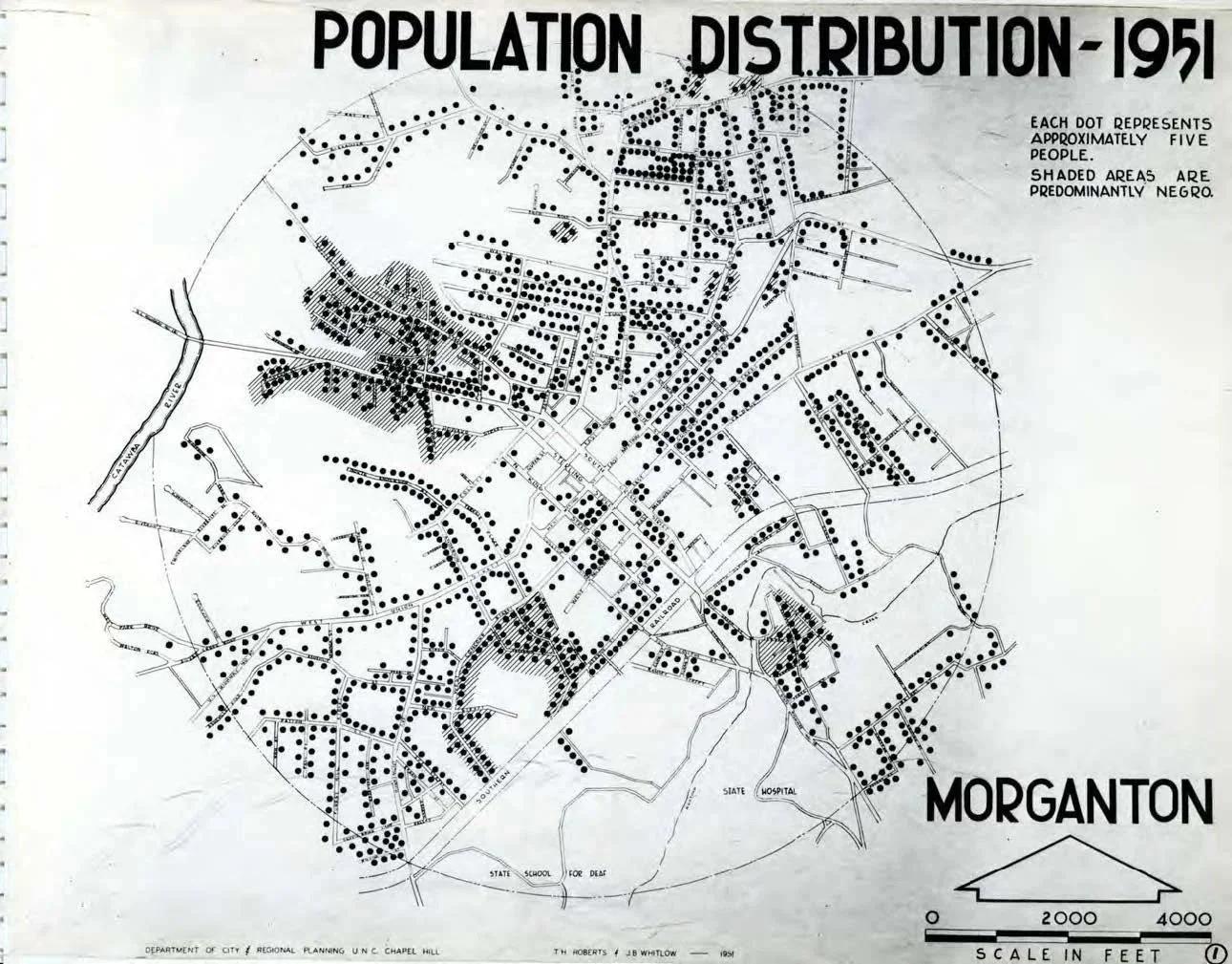
Map A: Morganton’s Population Distribution (Roberts and Whitlow, 1951)
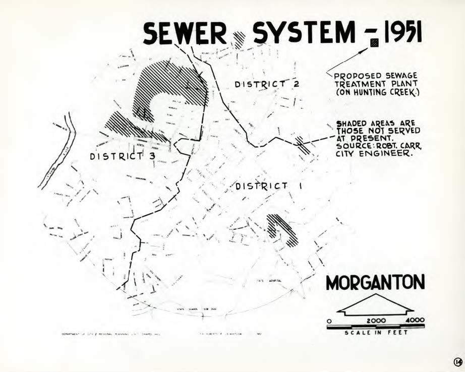
Map B: Morganton’s Water Utility Service (Roberts and Whitlow, 1951)
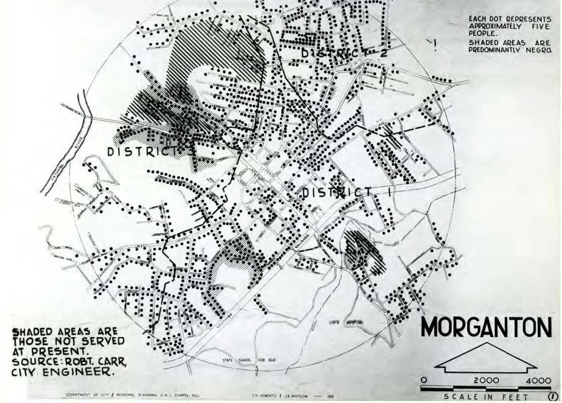
Map C: Morganton Population Distribution Overlay Water Utility Service (Wardzinski, 2023)
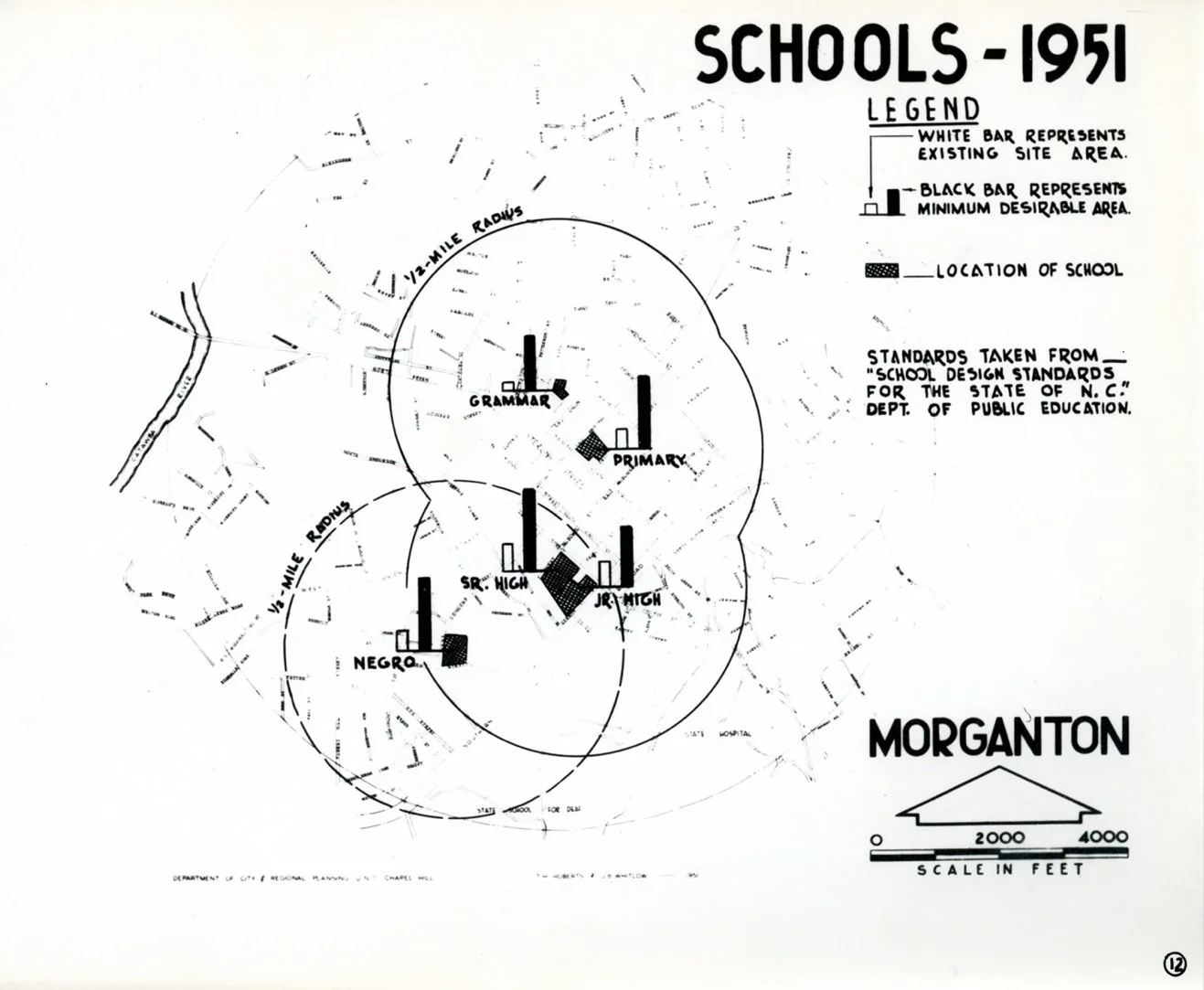
Map D: Morganton’s Schools (Roberts and Whitlow, 1951)
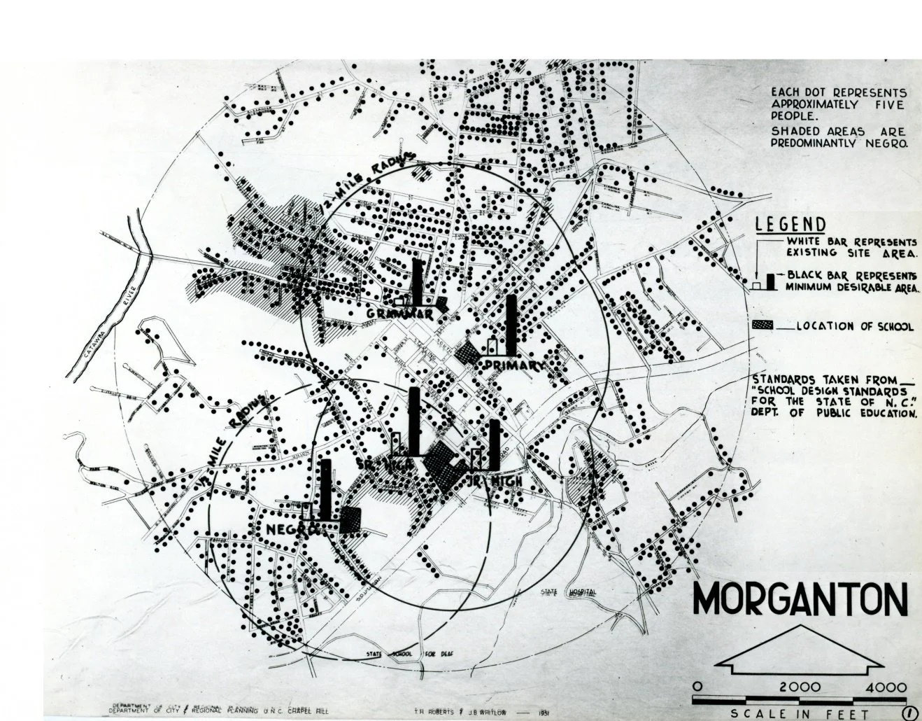
Map E: Morganton Population Distribution Overlay Schools (Wardzinski, 2023)

“The Valley Section” Patrick Geddes
Regional Planning by the Tennessee Valley Authority [Source: “Tennessee Valley Authority,” Architectural Forum, (Aug. 1939): 79]
Dissertation Focus: A Model for the World
Mapping Postwar Planning Pedagogy
In the spring of 2018, I came upon seven dusty boxes in the storage room located behind the planning library at the Department of City and Regional Planning (DCRP) at the University of North Carolina. Within these boxes, I found twenty-two master theses spanning the years between 1951 and 1959. Dispersed within these booklets were countless articles from local North Carolina papers touting the work of the UNC "Missionaries of Planning." DCRP students did this planning work in a collaborative graduate-level studio project with the Tennessee Valley Authority (TVA), the federal agency that had provided seed money for the department in 1946.
Once these artifacts of early post-war planning pedagogy were located, I began layering the student's original diagrammatic analysis of North Carolina towns using a modern rubric (see maps A + B from Morganton, NC). The goal of the layering process was to give insight into which population the TVA and UNC students were serving and which they left without consideration. The method which subjugated the voices of Morganton's African American population was the norm repeatedly found in the other 21 documents.
These maps represent a pivotal moment in my research which moved my dissertation from speculation to dimensional fact. The TVA considered the DCRP as its training arm for the future generation of planners and would spend the Cold War exporting the lessons learned in the American South to decolonizing nations around the globe.
Take a moment. Consider that.
The result of this layering, map C, demonstrates that the students' assertion that "Practically all areas of Morganton are well served by the existing water facilities, which extend for some distance into the county" is accurate with regard to the white population of Morganton. The students went on to suggest that an updated water treatment plant would bring the community to modern standards of sanitation. They proposed a site for this plant at the confluence of the Catawba River and Hunting Creek. This was—and continues to be—an area primarily populated by the African American residents of Morganton. With this recommendation, Morganton pursued federal grants for its construction and the plant remains there today.
The result of the further layering of Morganton's maps helps to extrapolate the impact of zoning suggested by the students. The students' recommended zoning delimitation would displace over 125 African Americans in the southeast area and in parts of the northwest area of Morganton if zoned as areas for industry rather than for residential use. This, too, was agreed upon by the city and implemented.
The most significant finding which resulted from the layering technique was the complete failure to comply with all commonly accepted planning standards for the time. These standards suggested that it was unwise to situate a school a mile from the neighborhoods which it served, and indeed it would be ill advised to situate a school in a location that required children to cross a railroad track to attend. When applied to Morganton's one African American school, these principles show the proposed plan for the future of Morganton as woefully inadequate. The school designated for African Americans served students from three separate neighborhoods, one over a mile away and another located across a busy industrial railroad track. According to the graduate students’ zoning suggestions, this railroad track would only become increasingly trafficked if Morganton's master plan was accepted.
Rethinking the Tennessee River and its Tributaries
Site research is paramount in the way I understand the world. In fact, it is possible that I best understand the segregated city of Morganton because it is the town in which I grew up and I experienced the implied lines of segregation in my childhood. My elementary school was the first to be integrated after years of push back following the Brown vs. Board of Education decision.
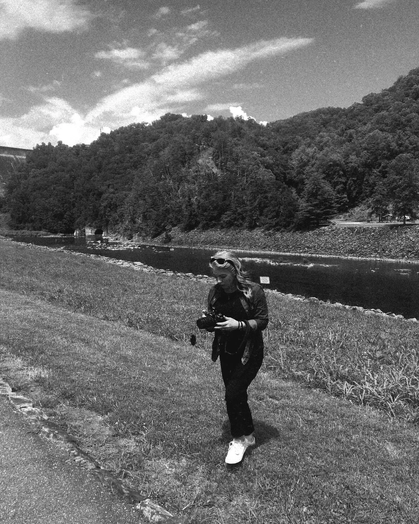
It is also true that when I attempt to understand the Tennessee Valley, I find that walking the banks of the Tennessee River and its tributaries, paddling its waters, and scaling its banks is the best way to get to know the land. It is on the land that I understand the three-dimensionality of my research.
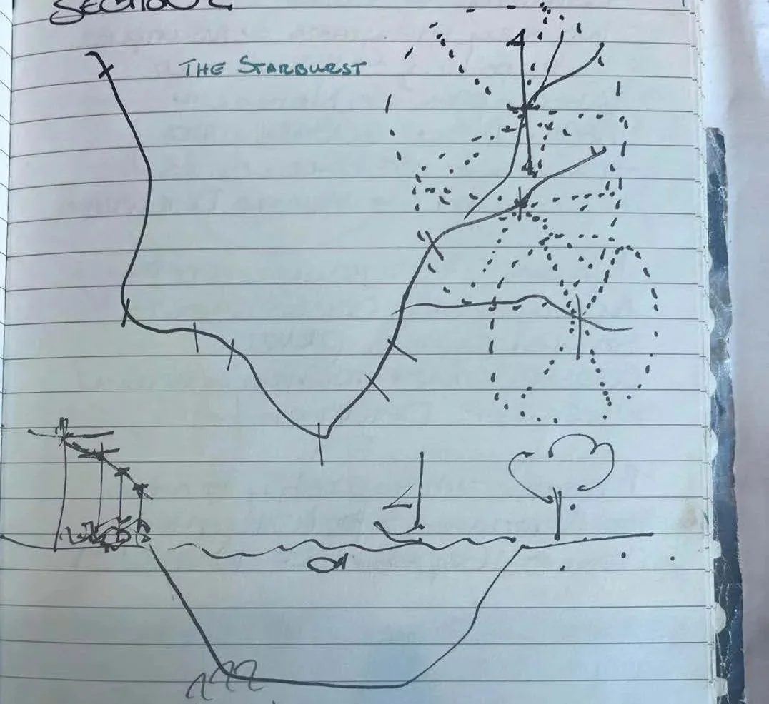
Photographs often act as a useful examination of the built environment and the impact of the TVA, but speaking to the family fishing below the dams is even better. However, I have found that my own process often results in sketching thoughts that are hard to put into words. When I am able to fuse theory, history, and sketching, I am able to reach deeper comprehension of my experience.
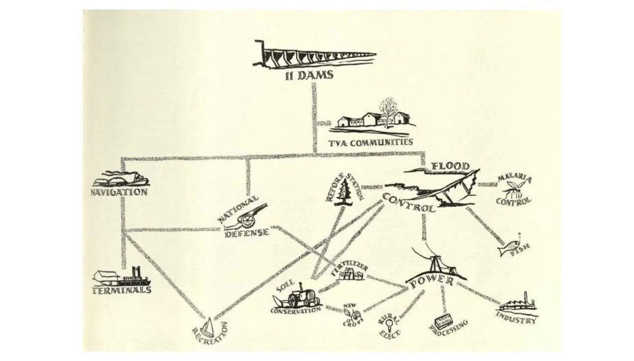
I offer a notebook sketch that, in particular, has led to new ways of thinking about the TVA as a model of regional planning. It is this interpretation of regional planning that I explore as the exported model of regional planning in the post-war era. This model uses an ever-changing definition of the boundaries of a region. The theoretical stance is derived from the TVA Act which states that the region is confined to the Tennessee River and its tributaries. Using Patrick Geddes's "Valley Section" as a starting point, I posit in this sketch that to understand the valley as a region, the section—as a drawing convention—must be viewed as one which has an undefinable depth.
The valley is described figuratively as inclusively encompassing at all times the river, city, farm, mine, and so forth. But if we understand the section as a drawing typology, then we can also consider the region in plan. Positioning electricity production in the form of TVA dams along the river demonstrates in two dimensions that the region is not bound by the river, it is bound by the length electricity can travel over the course of power lines. In 1933, this distance was 300 miles, by 1945 the distance was 450 miles. Thus, creating an ever-changing delimitation of the region and thus an ever-changing dominion of control.
*This original concept is cited in The Garden and the Machine: Planning and Democracy in the Tennessee Valley Authority by Avigail Sachs.